Hradec Králové Region
The Region of Hradec Králové is situated in northeastern Bohemia and covers the territory of the following five districts: Hradec Králové, Jičín, Náchod, Rychnov nad Kněžnou and Trutnov. With an area 4,758 square kilometers and a population of 548, 368 inhabitants (as of Dec 31,2005) it belongs among the smaller regions of the Czech Republic. In the north it borders with the Liberec Region, to the west with the Central Bohemia region and to the south with the Pardubice Region. The part of its northern and eastern border is as well the state frontier with the Polish republic.
Basic Information
| Area | 4,758 km² |
| Population (as of Jan. 1, 2000) |
551 651 |
| Seat of the region | Hradec Králové |
| Number of municipalities | 448 |
The land relief of the region is very variable and consists of all types of the countryside. There is a flat country in Polabí, hilly areas in Podkrkonoší
and Podorlicko and the Bohemian mountain border range. In its highest part, the Krkonoše Mountains, we can find the highest mountain of the Czech republic Sněžka
(1, 602 meters above sea level). In the Krkonoše Mountains originates the most important river of both the Hradec Králové Region and Bohemia - the Labe.
With its tributaries Úpa, Metuje, Orlice and Cidlina, it draws the water off the most part of the region.
The favorable transport accessibility in Hradec Králové Region is based on its compact railway network. The country - wide fast train railroad tracks covering - Prague - Hradec Králové - Týniště nad Orlicí - Letohrad, Pardubice - Hradec Králové - Jaroměř - Liberec, Jaroměř - Trutnov a Týniště nad Orlicí - Náchod - Meziměstí, are supported with side tracks that connect all parts of the region to the state railroad network. The Region is covered with 590 kilometers of railroad tracks (14% of these are electrified) and there is also a railroad border crossing with Poland in Meziměstí.
The road transport is based on two first class international motorways (Liberec - Jičín - Hradec Králové - Brno and Praha - Hradec Králové - Jaroměř - Náchod - Poland) However, these will soon be replaced by the D11 highway, which is just being completed in the part between Libice nad Cidlinou and Hradec Králové and also by prepared high speed R35 motorway from Turnov - Jičín - Hradec Králové to Moravia. The dense road network of the region including both mentioned cored motorways consists of km 433.9 of first class roads, km 900.9 of second class roads and km 2, 423.2 of third class roads. There are also six road border-crossings with Poland: Pomezní boudy, Královec, Meziměstí-Starostín, Otovice, Náchod-Běloves and Orlické Záhoří.
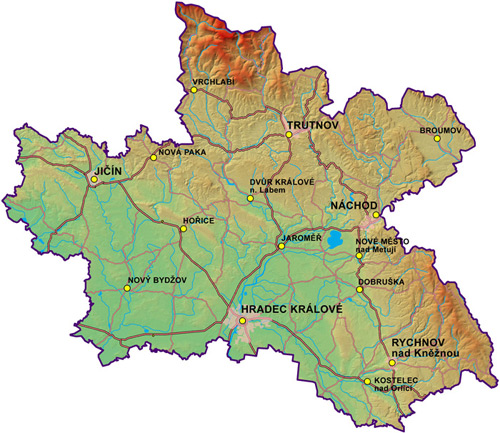
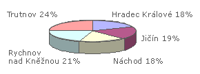
District area within the region
| Area | |
|---|---|
| Region/County | km² |
| Czech republic | 78 864 |
| Hradec Králové Region | 4 758 |
| Hradec Králové | 875 |
| Jičín | 887 |
| Náchod | 851 |
| Rychnov nad Kněžnou | 998 |
| Trutnov | 1 147 |